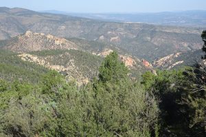
16-20 September: North of Silver City, N.Mex., we drove along the scenic but narrow, hilly, and winding Highway 15 over a high pine-forested ridge in Gila National Forest. This highway was once a wagon road built by the U.S. Calvary to hunt elusive Chiricahua Apache warriors. Geronimo was born and raised in these mountains near the headwaters of the Gila River. We camped at Mesa Campground on Lake Roberts, where met Bob and Jean, and visited with them after dark to watch a flyover by the International Space Station and share dessert. Our objective in this remote area was to see Gila Cliff Dwellings National Monument the following day, still farther north on Hwy 15.

For many centuries before the Gila cliff dwellings were constructed, the people of the Gila River headwater region had lived first in pit houses and later in above-ground pueblo style houses. They shared similar cultural traditions with people across a region that includes parts of present-day Arizona, New Mexico, Texas, and northern Mexico. This region and culture were named by archaeologists Mogollon, after the mountains near its center. The Mogollon Culture coexisted with but was distinct from Hohokam Culture to its west (as at Casa Grande) and Ancient Puebloan (aka Anasazi) Culture to its north (as at Mesa Verde and Chaco Canyon).
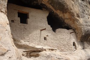
The cliff dwellings in the monument consist of about 40 rooms built into a set of alcoves and natural caves in the face of a cliff overlooking Cliff Dweller Creek, which flows into the West Fork of the Gila River. This complex was constructed of rock, mortar, and timbers that were cut from 1276 to 1287, then it was abandoned in the early 1300s. The Apache appear to have moved into the Gila River area from the north, probably in the 1400s, after it had been abandoned and before Spanish contact. The ruins of the Gila cliff dwellings were reported after an 1878 prospecting trip, but looters had taken many of the artifacts before the first archaeologist arrived to study the ruins in 1884. Miners, ranchers, and loggers arrived in increasing numbers after the Apache Wars ended in 1886. The site was finally protected against additional damage and vandalism when it was proclaimed a National Monument in 1907. Forester and pioneering ecologist Aldo Leopold persuaded the U.S. Forest Service to establish the Gila Wilderness in 1924, the first designated wilderness in the country. A one-mile loop trail goes up to and through the ruins, with informational signs explaining the history of the ruins and describing the life style of the people who lived there.
In the afternoon, we hiked a while on the Continental Divide Trail, heading south from the Sapillo (“little toad”) Campground trailhead onto the crest of a ridge with fine views and many century plants.


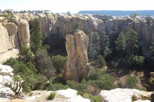
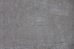
Our next stop in New Mexico was El Morro National Monument. When we arrived, we fortunately found one unoccupied site at the small, free campground in the monument. We enjoyed meeting and visiting with Mainers Chuck and Linda, camped in the site next to ours, and hiked with them the next day. El Morro (“headland” in Spanish) is a steep rocky promontory that was a well-known landmark along a major east-west trail since ancient times, with a pool of water at its base that was an important resource for travelers heading across the desert. The Zuni people built a multiple-story pueblo large enough to house about 400 people (now known as Atsinna Pueblo) on top of this headland around 1275. In Spanish colonial times, explorers, soldiers, and priests traveling the route from the Rio Grande to the larger Zuni Pueblo farther west would stop at El Morro on the way. Some of these travelers began to inscribe their names on the smooth vertical rock at El Morro’s base alongside native petroglyphs carved earlier. After the U.S. obtained the New Mexico territory following the U.S.-Mexican war of 1846-1848, American army expeditions, railroad survey teams, overland travelers to California, and even a camel caravan began to add their names to “Inscription Rock.” When railroad service began in 1881 across the Continental Divide 25 miles to the north, the long-distance route past El Morro became obsolete. In 1906, El Morro became a National Monument, making further carving on the rock illegal.


The hike we took with Chuck and Linda was the two-mile Headland Trail, a loop up onto the top of El Morro, through the ruins of Atsinna pueblo on top, around the top of a beautiful box canyon, and down the other side. We also walked the half-mile Inscription Rock Trail, that loops close to the carvings and pool. The visitor center has excellent displays highlighting the history of the successive cultures of the area, as well as some of the artifacts found at the site.


As we started east after one night at a campground near Albuquerque on our way to Texas, Paul’s third cousin Dennis and his wife Lou, whom we had first met on our 2019 trip with Vagabond, gave us a warm send-off when they visited us at our campsite, bringing breakfast burritos and bacon. It’s nice to have a personal connection to enrich our future visits to the Land of Enchantment!


