25-28 September: We broke up our long drive from central Arkansas to northeastern Tennessee with a night in Natchez Trace State Park. A lasting memory of that brief stop was spotting a rattlesnake while on a run before supper. It was tiny, only about 6-7 inches long, and at first looked flat, as though it may have been run over. The body had dark splotchy bands against a beige background and the head had a dark eye stripe. When gently touched with a long thin twig, though, the little snake turned its head toward me, opened it mouth wide to show its fangs, and shook the tiny, yellow, noiseless rattle at the end of its tail. A yellow tail tip is characteristic of juvenile pigmy rattlesnakes.
The next day we stopped in Knoxville to see the gravestones of Alfred and Emma Martine, uncle and aunt to Paul’s great grandmother Lowry, and then we camped about an hour farther north. Alfred was a civil engineer who lived for a time in Middlesboro, Kentucky, very close to our next destination: Cumberland Gap.
After arriving at the Cumberland Gap National Historical Site and getting a campsite, we saw the exhibits and video at the visitor center and then went for a bike ride on the Wilderness Road bike path. This is a pleasant wooded trail headed eastward from a parking lot along the highway, but going westward the path becomes overgrown where it emerges from the woods onto the shoulder of the highway and no longer seems to follow the former railroad bed.
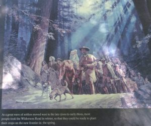
The following day we hiked 8.4 miles exploring the historic Cumberland Gap, which is near the present-day town of the same name. First, we followed the route blazed by Daniel Boone and others that became the Wilderness Road traveled by many American families seeking new homes west of the Appalachian Mountains in what would later become Kentucky. This gap was one of the few places suitable for a wagon road to penetrate across the long and steep-sided mountain ridges of this region that had previously been a barrier to trans-Appalachian migration. About 250,000 settlers crossed the gap into the Ohio River watershed during 1776-1810. Before 1800, Kentucky and Tennessee became our 15th and 16th states and the Wilderness Road was improved to accommodate wagon traffic. The importance of the road declined in the 1830s and 1840s, when canals and railroads were built in other areas. A railroad tunnel was finally completed under Cumberland Gap to Middlesboro in 1889. The highest point (“saddle”) in the gap had been substantially altered by road building in the 1920s, but it was restored to its original Wilderness Road configuration by the Park Service after motorized traffic was rerouted through a newly constructed highway tunnel in 1996.
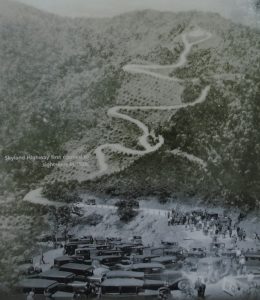
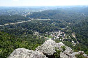
From the saddle of the gap, we hiked up to the point where the boundaries of Virginia, Kentucky, and Tennessee meet. The trail to Tri-State Peak passes through the former site of a Union fortification that was blown up in a huge explosion when it was abandoned in 1862 to prevent leaving any munitions behind for the Confederates. Returning to the saddle, we hiked up a beautiful woodsy trail to Pinnacle Overlook, high above the gap. This viewpoint became a popular tourist attraction when the Skyland Highway was built to it in 1929.


Beyond Pinnacle Overlook, we saw only two other hikers all the way back to the campground. Ridge Trail followed the long crest of a ridge, generally following the Kentucky-Virginia boundary through a pleasant hardwood forest. On the ground there were lots of hickory nuts that were oval with a round cross-section, not quite an inch long, with a very thin husk (bitternut hickory?). Lewis Hollow Trail took us downhill from the ridge crest to the campground. We enjoyed visiting with Elliot and Katherine from North Carolina, camped two sites from us in an Ascape camper. They were among the relatively few hikers we met on the trail all day.


